At the very beginning of this chapter we would like to pose a question to ourselves and to you—potential readers: what are we really searching for? El Dorado or Paititi? After reading many resources related to Paititi we have found out that the search for the last capital city of Incas has been melted with different legends describing a city full of gold etc. etc. And like this the history witnessed expeditions of Spaniards down to the río Amazon and its surroundings in the search of the city called Manoa supposed to be situated on the shores of the lake Parime [1] or more recently the expedition of Lieutenant Colonel Percy Fawcett searching for the mythical city of “Z”.
In our historical overview we will not focus on expeditions hunting a legend but on expeditions trying to find the last capital of Incas—Paititi. Let’s get virtually back into 16th century in Peru. The Spaniards have everything under their control. Their last problem—Vilcabamba and its possible influence on the folk still remembering good times without Spaniards is over. If the Incas were able to save anything from their culture, traditions, treasures, nobility… Then where would they have gone and what would they have done?
Vilcabamba was the last point of resistance with “the government in exile” but there was still a theoretical chance of expelling Spaniards at least for a certain time out of the kingdom of Incas and to restore the old kingdom as it was. But after Vilcabamba was conquered by Spaniards even that last possibility had no chances anymore. The time of Incas was over and they had to give up. They had to go somewhere where they could at least survive—to Paititi. For them it would be the second and the last exile—the point of no return. They would know that from now they will be not able to exercise any power on the rest of their former kingdom. They had their little territory, their city which they tried to manage as good as possible…
And here we are: we can easily become victims of wishful thinking. We can’t imagine the suffering of that folk at the time of Conquista but we still wish to find the last refuge of Incas somewhere on top of the mountain with roofs covered by gold and waterfalls around it. A kind of another Machu Picchu with its splendid buildings…The reality is probable much different: Paititi is hidden somewhere in a valley surrounded by mountains, not exposed and not revealing its mystery.
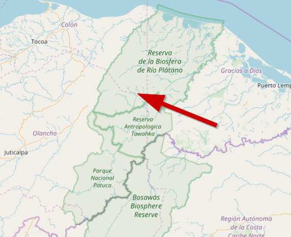
Just very recently the lost city of Monkey God (Ciudad Blanca) has been discovered in the jungles of Honduras with the help of methods very similar to ours [2]. We don’t know much about the civilisation that created it but we know that they were living somehow in the shadow of Mayas—a powerful civilisation just next door to them. And perhaps that’s why Ciudad Blanca remained undiscovered for such a long time. Both Ciudad Blanca and Paititi protected their existence by being hidden from the eyes of a powerful neighbour. And while Ciudad Blanca finally revealed its secrets to the scientists, Paititi, until now remains undiscovered but we guess that the time of its discovery is imminent.
A Short Analysis of Some Most Significant Expeditions Searching Paititi
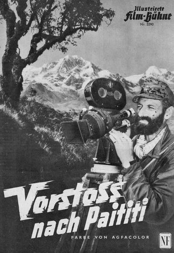
Expedition of Hans Ertl (1954/1955)
Led by a well-known German film-maker and mountain-climber to the lowlands of Bolivia. The aim of this long-lasting expedition was to explore the jungles in the surroundings of the río Santa Ana where local people were using the name “Paititi” not only in their legends but they also gave this name to one peak situated in that area—Cerro Paititi. And indeed the expedition didn’t return back empty-handed. Apart from ancient terraces and rests of walls they found a gold mask and many other artefacts made from precious metals or carved stones. The most significant result of the explorations was the discovery of an Inca cult place allowing them to observe the rising sun through the cleft in the mountain range.
Expedition of Nichols/Nicholsson (1970)
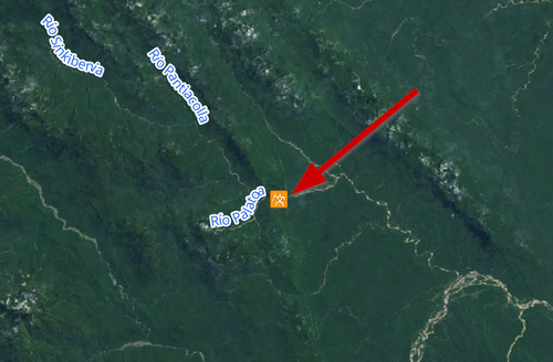
Here we have a kind of mysterious story. An American journalist Robert Nichols (or Nicholsson by some resources) accompanied by two French fellows tried to explore the río Sinkibenia up to its source but then, after a shortage of supplies they had to turn back following the río Maestrón/Nistrón and around the point of its confluence with the río Yungari all the members of the expedition got killed. A few years later Yoshibaru Sekino, a Japanese law student followed his steps and learned that the French members of the expedition tried to have a kind of “closer contacts” with some women of the Machiguenga tribe giving the opportunity to their husbands to make the long story short. But without being nasty in our estimations about what happened and what did not happen: it’s very possible that the expedition simply ran out of its supplies (not the first and not the last time in history of expeditions) and (according to some other testimonies) they saw one empty Machiguenga village while sailing down the río Nistrón. They were exhausted, they were on their last legs and they grabbed whatever was available to eat… That village seemed empty but inhabitants and warriors were waiting just a few meters away… And Machiguengas are usually quite friendly people… They love to get presents but they hate if somebody is taking something from them without permission… We don’t know how the bells of the Hell sound… We can just imagine…
Expedition of John Blashford-Snell (2001)
Generally speaking British explorers don’t like any modern approaches while doing their job nor do they trust anything not proven before. John Blashford-Snell was no exception—he and his expedition made progress into the jungles of Bolivia with the help of God and dynamite. The thing is that occasionally even the simplest methods can have very complicated outcomes and unfortunately this was the case of John Blashford-Snell’s expedition. I still remember very well that while still a student, my professors hated whenever I used in my works citations originating from translations from an original resource. And while planning his expedition, John Blashword-Snell was using a Spanish translation of Hans Ertl’s book as his resource, which seemed to have been done as really simple, similar to the stories from a barber’s shop—somebody tells a story to a barber, a barber forgets some parts of it while estimating the right portion of hair to be cut but he adds some pieces to it straight after this and a new story is born just for the barber’s next customer. After analysing that Spanish translation, John Blashford-Snell was sure that Hans Ertl had discovered Paititi together with its immense treasures without revealing its position. Following vague remarks from the Spanish translation he was more or less copying Hans Ertl’s expedition trail adding some new minor discoveries, in form of pottery, carvings, ancient Inca walls in the area surrounding Cerro Paititi but the real joker—Ciudad Paititi—still remains hidden somewhere in a jungle.
Nevertheless, apart from the land expedition there was also a sailing part of it, called Cota Mama III, which chose Lake Titicaca as the starting point. Its aim was to prove that ancient Incas were able to use a rich net of rivers on the eastern side of the Andes to trade with other tribes along them as far as the Atlantic Ocean. The expedition used for this purpose balsa boats similar to those used in the expeditions Kon-Tiki of Thor Heyerdahl half a century before and in the same way similar to those made by the Uros tribe living on floating islands on Lake Titicaca in Bolivia. The scientific success of this part of the expedition had been underlined by reaching Belem in Brazil, close to the shores of the Atlantic Ocean. Frankly speaking—Cota Mama III was of a speculative character but to be honest—is there any science without some speculation at its starting point?
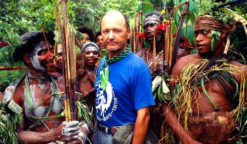
Expedition of Jacek Palkiewicz (2002)
Well… A kind of heavy-metal expedition. With support from Polish, Italian and Peruvian governments it was one of the best equipped expeditions ever undertaken in this region. Palkiewicz is one of the most important players in the international ring of “who is who” in the field of geography and discoveries in this field—just a reminder: Palkiewicz has discovered the exact position of the sources of the río Amazon, he is a member of the British Royal Geographical Society. Following the advice of Juan Carlos Polentini Wester, a Salesian priest who spent basically his whole life in the search for Paititi, and having in their disposal modern satellite imagery from American commercial satellites they have explored the río Choritiari (a tributary of the río Nistrón) and an unnamed plateau situated on its right side. Apart of some stones being a part of an ancient Inca trail the expedition hasn’t discovered anything significant. At least this is the conclusion after reading his book. However, information related to this expedition and presented in a Polish version on Palkiewicz’s personal website (the English one is still not available) sounds slightly different. Unlike in his book, he claims here that the expedition hasn’t found just single stones of Incas’ origin but the rests of ancient buildings probably forming the suburbs of Paititi and traces of a square lagoon covered by vegetation. Also the reason for the K.O. of the expedition is presented on his website in a different version: due to a shortage of supplies while in his book he writes that it was necessary to bring one member of the expedition back to civilisation because of a snake-bite. Which version can we trust more? Both of them agree in fact that Palkiewicz desperately tried to show his position to Russian cosmonauts on board of the International Space Station who were supposed to give him some more clues as to the orientation of his further movements with the help of high-resolution images (resolution 1m per pixel was considered top level at that time) made by them from orbit and soon after his attempts to contact them failed, his expedition came to its end. Surprisingly, he has never published any pictures of any remains of ancient buildings or traces of a square lake that would give a credit to his words, so it is possible to conclude that this kind of discovery never took a place.
Expedition of Tahir Shah (2003?)
A low-budget expedition of a British author, journalist and explorer. Accompanied by 2 Swedish film-makers, a Russian banker and a guide from the Machiguenga tribe who claimed to spot huge ruins in the jungle while hunting. They explored by boat the río Palatoa and some areas around it but without any discovery. Picking up on the positive side of this expedition: while getting started, he questioned with the typical Arabic sophistication an unknown number of explorers searching for Paititi as to the possible whereabouts of this legendary city and he concluded that it must be situated somewhere between the río Piñi-Piñi and the río Palatoa [3]—Maybe a great tip for all of us obsessed with this subject? Tahir Shah gained through his travel enough material to write a really nice book about his expedition showing that… NOTHING IS IMPOSSIBLE!!!

The Heavyweights in the Quest for Paititi
Carlos Neuenschwander Landa
He was probably the most important researcher who shed some light on uncharted territories of the Madre de Dios Region. Born in 1914 in Arequipa, Peru, he began his explorations in 1954 in and around the valley of Lares and was the first scientist who documented and described the Hualla fortress. In the following years he led numerous expeditions to the area of Cordilliera Paucartambo and beyond, travelling on land, on rivers and by helicopter and discovering Camino de Piedras—a kind of central trail of Incas passing from south to north along whole Cordilliera Paucartambo. Carlos Neuenschwander Landa was not just guided by his instincts—he had a chance to interview 2 persons independently claiming that they had seen Paititi—a Peruvian Angelino Borda who spent 3 years in the custody of Machiguengas and a Machiguenga Celestino. Their testimonies were in many points very similar and it seemed to be an easy task to localize Paititi. But apart from spotting a few significant places pointing to Paititi like a mountain with 5 peaks, Laguna Negra or Laguna Quadrada his search for the last capital of Incas remained without success.
Gregory Deyermenjian
From our point of view—the 2nd in the line of the smartest explorers searching for Paititi. Looking closer at the areas covered by his research we have got a feeling that he was following a very similar pattern like we are: take the best and leave the rest. He became interested in the subject of Paititi when he first visited the ruins of Vilcabamba in 1981. Since then, he focused mostly on the high-altitude areas of the Cordilliera Paucartambo and the Pantiacolla Plateau expanding on the researches done by Carlos Neuenschwander Landa with whom he occasionally cooperated and who believed that Paititi must be situated somewhere there, along Camino de Piedras. Known as “Diferente que los demás” (Different than the others), a name given him by Machiguengas of Mameria in their language, Greg Deyermenjian is a tough guy following his instincts and his experiences—regardless if the path is following mountains or leading down to the jungle, as Mr. Gene Savoy said once in his well known book Antisuyo: “Follow the paths, they will lead you to ruins”. And that’s what he is doing. He discovered many still unknown ancient Inca ruins along Camino de Piedras and he definitely earned his position at the virtual Hall of Fame of Paititi researchers.
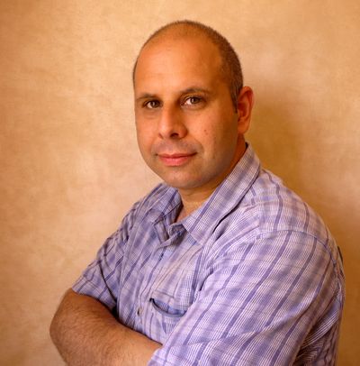
Thierry Jamin
The youngest one and perhaps the one who fully earns the definition of “Enfant terrible” in the quest for Paititi. We can imagine him doing in his childhood the same things as we did—leading his finger over the jungles shown on maps in a world-atlas and dreaming to discover something unique, something extraordinary. But exploring uncharted areas in the South-American jungles we should learn some lessons from the past explorers. We should mix the poetry of our fantasy with conservative views and experience of our predecessors and Thierry Jamin seemed to ignore this approach.
Our likes:
He is never tired to enter the Peruvian jungle handling his expedition as a goal on its own.
Our dislikes:
By his website and movies published on YouTube etc. he loves to present himself as a modern Indiana Jones, he explains to the innocent folk the meaning of Pusharo petroglyphs and he claims to find at the Machu Picchu site a chamber full of gold and silver while using on its localization the most expensive but in the same time the most doubtful type of metal-detectors made by a company called OKM [4]. Instead of inviting a team of geophysicists operating a proper georadar which would give much higher credibility to his discovery (just for the simple fact that there is no existing real metal-detector showing chambers and metals at depths of 7 meters and more). [5]
But without criticizing too much: he led many expeditions to the Sanctuary of Megantoni, he discovered some minor Inca ruins there too and recently the focus of his explorations is concentrated on the area of headwaters of the río Timpia, where he localized a square mountain and a lake with a square shape. Well…what should we say? Buona fortuna… That’s not from the Indiana Jones’ movie, that’s from the last James Bond’s film.
Herbert Cartagena
Let’s cover the description of the discoverer of Mameria in a very simple but accurate way: a guy knowing a lot, talking very little and that’s all we know about him.
Juan Carlos Polentini Wester
Last but not least we would like to mention this very extraordinary person who became a researcher of Paititi while being guided directly from the highest instance—from the God in whose duty he had spent his entire life. In his first book “Por las Rutas del Paititi”, he gave us a brilliant account of his travels to the homes of believers in the area of Lares. During his walks he mapped and described basically all important ancient Inca paths in that area and concluded that all of them led this or that way from Cusco to Cordilliera Paucartambo and beyond and thus giving a pretty good starting point to all further explorers.
Unfortunately, we have to give up but we are not able to say what happened really between the publication of his first and his second and last book: “El Pai Titi, Padre Otorongo” in 1999, in which he revealed the exact location of Paititi. We can only guess that this happened after he read the reports of Vincente Cenitagoya and those of Juan Bovo de Rebello mentioning the existence of two big cities situated on the slopes of Apu Catinti [6]. What made him to present his “find” at a public lecture, and in his book, which allowed Greg Deyermenjian to make an investigative expedition to the area, the next year, to reveal that it contained nothing of the sort? Why did he lure Palkiewicz to go to the same site again three years later? And why after all this, he still accused the ex-president of Peru, Fujimori, of stealing the gold of Paititi?
“Blessed are those who have not seen and yet have believed”. (John 20:24–29 ESV)

Hot Spots in the Quest for Paititi
Mameria
Discovered in 1979 by Herbert Cartagena. Since then visited by numerous expeditions. The importance of the site as the stronghold overviewing the paths leading to the heart of the Incas’ Empire was probably influenced due to coca plantations in the areas surrounding Mameria and being important for the population of Incas’ Empire living in highlands. There is no evidence of its connection with Paititi. After Spaniards gained control over the Inca Empire and especially after they destroyed Vilcabamba—the last official capital city of Incas, Mameria lost its importance and… Paititi could be still the last significant point of the kingdom.
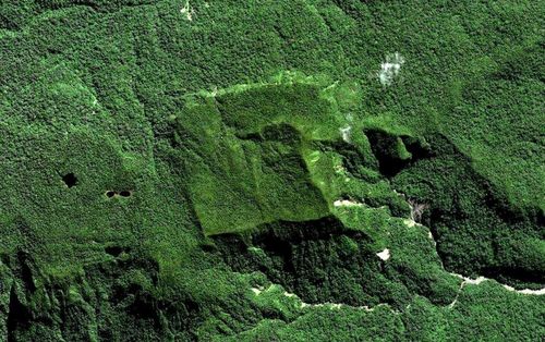
Pyramids of Paratoari
Perhaps many of us have already heard stories when a millionaire won the lottery or the contrary—somebody who by chance survived an attack of terrorists and got killed next day in a car accident. We bet that nobody seeing for the first time pictures of those perfectly symmetric structures produced by NASA in 1976 [7] would expect them to be just a game of nature. Looking like human-made objects and visited by countless expeditions they proved to be (here we have to add also so called square lakes related with Paititi—according to our researches it’s quite a common shape in this region) just normal, natural, perverted phenomenon known by everyone searching for Paititi.
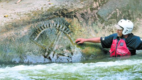
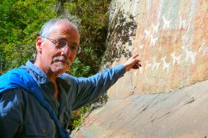
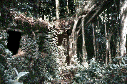
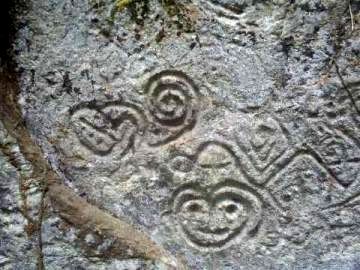
Petroglyphs of Pusharo
Probably the first documented visit was done by a Dominican missionary, Vicente de Cenitagoya, in 1921. Since then it has been visited and researched by various expeditions—C.N.Landa, G.Deyermenjian, T.Jamin and many others—nowadays accessible for tourists, tours are arranged by some travel agencies in Peru. Some researchers claim to find in the petroglyphs a kind of a road map to Paititi. Those claims are mostly based on placing a topographical position of various rivers in the region over the sheet presenting Pusharo petroglyphs and then by turning those 2 objects into different angles between themselves they were able to find the positions of the rivers passing through the region and in the same time passing somehow between the petroglyphs and thus showing a “map”. It’s a way showing a “wishful” connection between the mystery of Pusharo and the logic and knowledge of Templar Knights as we know from various places in Europe. But in the case of Pusharo, nothing can be more wrong because we can find different solutions using different angles…This kind of puzzle is useless because almost every angle has the potential to be the winning one… The only use of Pusharo petroglyphs is that we can admire them being there and perhaps we will share the same view as visitors admiring an ancient gallery of arts or a kind of prototype of Facebook created a few hundreds of years ago. Let’s enjoy it!
References
- El Dorado, Wikipedia, last modified 26.01.2018. Retrieved from https://en.wikipedia.org/wiki/El_Dorado
- PRESTON, Douglas. The Lost City of The Monkey God. New York, Boston: Grand Central Publishing, 2017. ISBN 978-1-4555-4000-6, p.49-51
- SHAH, Tahir. House of The Tiger King. London: John Murray (Publishers), 2004. ISBN 0-7195-6611-8, p.15-16, p.21
- Jungle Doc. Machu Picchu 2012 : The discovery and the geophysical survey. YouTube, 2013. Retrieved from https://www.youtube.com/watch?v=vxW13JXAt50
- OKM?? [Online forum thread], 2008. Retrieved from http://www.treasurenet.com/forums/geophysics/97457-okm.html
- EGIDO, Jesús. Paititi la ciudad perdida, 2017. ISBN 978-1365952197, p.165
- Paratoari, Wikipedia, last modified 25.02.2016. Retrieved from https://en.wikipedia.org/wiki/Paratoari